3D Print a Landscape Model
thingiverse
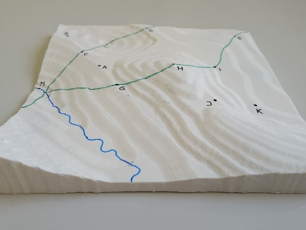
This is a fictional landscape model (15cm x 15 cm) that helps students better understand topographic maps. Exercises for using these models in geography or science classes are available here* or in Kristjan Rea's master's thesis, "Applying virtual 3D-models and physical 3D-models created by a 3D-printer for learning about the topic 'Landforms and Groups of Landforms' in basic schools." The link to the master's thesis is https://goo.gl/3Aq2gR. It's recommended that students participate in making the landscape model themselves. Here's how I designed this landscape model: Step 1: In Adobe Illustrator CS6, the top view of the landscape model (including contour lines) was created. Step 2: The Illustrator file was modeled in Blender 2.76 and then converted into an STL file. Step 3: After printing the model, paths (green), rivers (blue), and exercise points (black) were drawn by marker. Note: It's recommended to use a printer with a heated bed when printing this type of model. Here are some exercises for using this landscape model in class: Inspect the landscape model and answer the following questions. Write the correct letter on the dotted line or underline the right answer. 1. Where is the highest point of the landscape model located? 2. When moving from point I to point E, does the altitude decrease, stay the same, or increase? 3. Can you see point I from point G? Yes/No. Explain briefly! 4. Compare two slopes. Is the slope on the northeast side steeper than, equally steep with, or less steep than the slope on the northwest side of the landscape model? 5. Where is point B located in relation to point J? 6. In which direction does the river flow? 7. What location is point H? 8. Where is the lowest point of the landscape model located? 9. Where is point A located in relation to point H? 10. Which side of the landscape model has the steepest slope? 11. Can you see point D from point F? Yes/No. Explain briefly! 12. When moving from point D to point C, does the altitude decrease, stay the same, or increase? 13. What location is point M?
With this file you will be able to print 3D Print a Landscape Model with your 3D printer. Click on the button and save the file on your computer to work, edit or customize your design. You can also find more 3D designs for printers on 3D Print a Landscape Model.