3D United States Printable Map
thingiverse
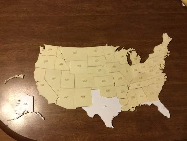
This project is a printable 3D U.S. Map. Inspiration for this project comes from the desire to help my two children succeed in their Geography and Social Studies classes. My children are in elementary school and are learning the states. This map has helped increase and fine-tuned their knowledge of the United States. Print Settings Printer: QIDI Tech Rafts: Doesn't Matter Supports: No Resolution: .3 How I Designed This Inspiration: This project was inspired by my children's needs and ambitions for learning the United States. Overview and Background Overview & Background: The 3D U.S. map is an excellent hands on tool for learning the states. After completing the map the student will be able to identify each state, their abbreviation, and their names. Lesson Plan and Activity Objectives: The 3D U.S. map will help students identify each state for geography and social study lessons. Custom Section Project Name: United States 3D learning map Overview & Background: The 3D U.S. map is an excellent hands on tool for learning the states. After completing the map the student will be able to identify each state, their abbreviation, and their names. Objectives: The 3D U.S. map will help students identify each state for geography and social study lessons. Audiences: The 3D U.S. map is designed for 1st through 6th grade students but I encourage all students that need help leaning states to us it. Subjects: Geography/ Social Studies Skills Learned: Students will learn each state by its shape and will be able to see the abbreviation of each state. Students will be expected to assemble the map, identify each state's name, and the location of the states. Lessons/Activity: Step one: Print the states Step Two: File edges Step Three: Students will assemble the map Step Four: Students will identify each state's name Duration: Ideally each student should have their own map to assemble during the state geography lesson. One 45 minute lesson for all students to identify each state and assemble their maps with the instructor's guidance. One 45 minute lesson for the student to assemble and name each state by themselves. Preparation: Students should have had some exposure prior to working with their maps. I suggest two to three days of lesson of the states. References: http://nationalmap.gov/small_scale/printable/reference.htmlhttp://nationalmap.gov/small_scale/printable.htmlhttps://www.google.com/search?q=united+states+reference+map&espv=2&rlz=1C1KMZB_enUS509US509&tbm=isch&tbo=u&source=univ&sa=X&ved=0ahUKEwiS_rbBi4zNAhXBVz4KHRv1CF0QsAQILQ&biw=1600&bih=799 Rubric & Assessment: Each student should know: Each state by shape: Location of each state: States names: State abbreviations
With this file you will be able to print 3D United States Printable Map with your 3D printer. Click on the button and save the file on your computer to work, edit or customize your design. You can also find more 3D designs for printers on 3D United States Printable Map.