Chicago Skyline 3D Map
thingiverse
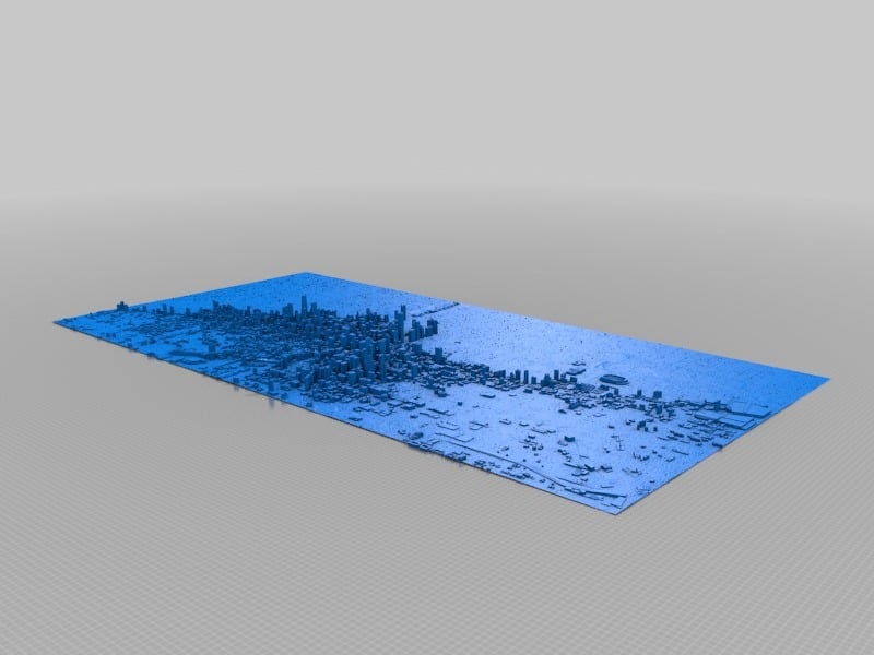
3D map of Chicago. The intent was to slice it into tiles for printing in sections - maps like this have been posted on social media sites but with no STLs and no workflow, so I wanted to offer both and maybe spark someone else to do a better job, but a hospital stay has me moving slowly for now. Here is the data I got done so far: Google's 3D data is proprietary, and ripping geometry from Google Earth like this is sort of a hack. I've done it before and it works, but the tools only work on Windows and IMO it's a rather messy process. OpenStreetMap also features accurate building height data like Google does, and while their models usually aren't as detailed as Google's (Google stores actual 3D models whereas OSM stores flat geometric shapes that have height data attached so they can be represented in 3D), it's free for the taking and the tools for doing so are much more straightforward. Also, I've found that the resultant geometry is much cleaner. So here's what I do in case anyone is interested in the alternative: 1. Export a .map region file from OpenStreetMap. Just click the Export button at the top of the page. The default area is the viewport, but you can also manually change that. Make sure the property you want is completely within the export region, then click the blue Export button to download the file. 2. Convert the OSM .map file to an OBJ model with OSM2World OSM2World is a free Java program for converting OSM data into 3D models. Just open the .map file in OSM2World with File >> Open, then export the whole thing as an OBJ via File >> Export OBJ file. That's it. 3. Import the OBJ into your 3D modeling application of choice and delete extraneous geometry before getting to work. And that's it. Whole process takes about 30 seconds! This map still needs to have a base added on, and sliced into tiles. I use Netfabb Free to slice things into tiles, it's fast and easy. Also, I wanted to make the ground more textured, I've been playing with using image to STL heightmap generators but haven'y had much time to get it perfect. Finally, the building scales should be pretty close to accurate now; exaggerating them may be nice but I was saving that for last since I'd prefer to have a realistic map as well as a height exaggerated one. Resources: https://wiki.openstreetmap.org/wiki/3D_printing_OSM_data https://www.youtube.com/watch?v=nVhM3IYMF8o https://wiki.openstreetmap.org/wiki/3D https://community.simtropolis.com/forums/topic/69935-tutorial-on-how-to-extract-3d-models-from-google-earth-to-get-dimensionsproportions-of-building/ https://forums.sketchup.com/t/copying-google-earth-cities-in-entirety-satellite-cartography-3d-models-for-other-3d-programs/43448/4 https://osmbuildings.org/ http://www.openstreetmap.org/ http://osm2world.org/download/ http://www.ocsmag.com/2015/10/26/open-3d-worlds/ http://blog.nadnerb.co.uk/?p=209
With this file you will be able to print Chicago Skyline 3D Map with your 3D printer. Click on the button and save the file on your computer to work, edit or customize your design. You can also find more 3D designs for printers on Chicago Skyline 3D Map.