Cho Oyu and Ngozumpa Glacier
thingiverse
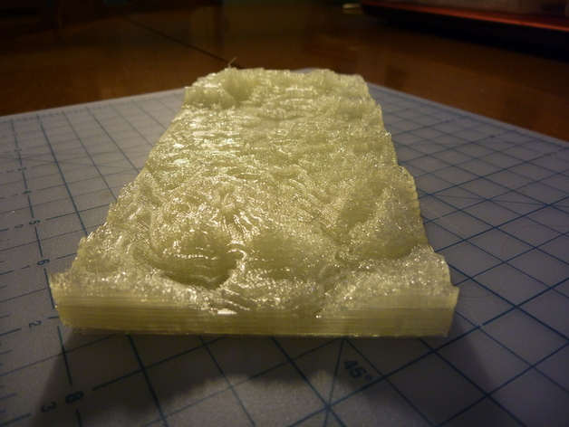
Cho Oyu, 6th highest mountain in the world, and the Ngozumpa glacier below it. Model has 4 quadrants (NW, NE, SW, SE) including Cho Oyu and the north end of Ngozumpa (NW), the southern end of Ngozumpa (SW), and two quadrants to the east including Mt. Everest (NE and SE). I printed the NW and SW quadrants for a friend's expedition to study the glacier. UPDATE: See http://www.thingiverse.com/thing:16851 for instructions on making your own. Now available at Github: https://github.com/bld/Cho-Oyu-and-Ngozumpa-Glacier Instructions The models were produced using Shuttle Radar Topography Mission 90-m resolution data. At a later time, I will post the recipe for doing this using data from anywhere. For the time being, I am posting Blender models - as displacement maps and as meshes - as well as the STL files. STL files are scaled for printing on a Makerbot Cupcake CNC with recessed screws. I used all open source tools: Geospatial Data Abstraction Library (GDAL) to convert SRTM HGT files to GEOTIFF GIMP to crop the GEOTIFFs Blender to produce displacement maps from the GEOTIFFS and meshes Meshlab to close the holes I found that the default scale of the Blender displacement maps was too flat. I did a test print and used calipers to get the scale right. Each pixel in X/Y is 90-m. To get the vertical relief correct, I measured the height of known parts of the map (summit of Cho Oyu and a nearby valley) and compared this to terrain maps in Google maps and the width of the model (200 pixels multiplied by 90m).
With this file you will be able to print Cho Oyu and Ngozumpa Glacier with your 3D printer. Click on the button and save the file on your computer to work, edit or customize your design. You can also find more 3D designs for printers on Cho Oyu and Ngozumpa Glacier.