Crustal thickness globe (updated)
thingiverse
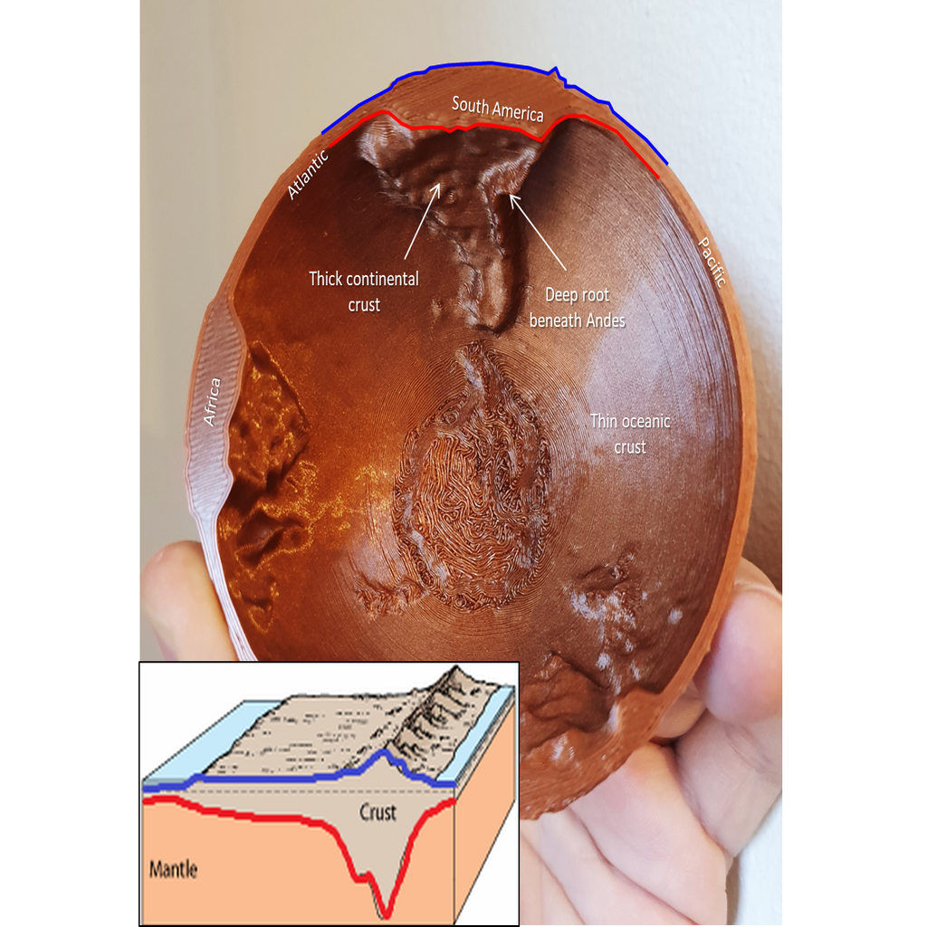
**Update 11/2019**: Added a second version which has correct crustal thickness and no space for magnets. This model has 50x vertical exaggeration This globe of the earth's topography opens to reveal the base of the crust (moho) which lies beneath it, an excellent aid for teaching and outreach in geology and geophysics. The relief at the surface and on the base of the crust are at the same scale (50x vertical exaggeration), and this is an excellent tactile way to explore the structures in the earth which lie beneath our feet The earth's topography (i.e. where the surface of the earth is higher or lower) is controlled in large part by the thickness of the crust. Since the crust is lighter than the deeper mantle rocks, crust is buoyant and therefore "floats" at the earth's surface (if you want to know more about this - google "isostasy"). What this means is that most high places like mountains have roots! Much like an iceberg, the topography we see at the surface is small compared to the amount beneath the surface. Notice how the thickest areas of the model are found in the Himalayas, where crust reaches 80 km thick, and beneath the high Andes. Correspondingly the deep oceans, where topography is at its lowest, are associated with thin crust. There are two models uploaded here: * The first version is scaled correctly to crustal thickness but has no space for magnets and therefore does not have a closing mechanism. It also has a small contact area with the print bed so may need to be printed with a raft if you're having adhesion issues. * The second version is designed to be printed with embedded 5x2mm neodymium magnets, by inserting gcode to pause the print and allow the magnets to be inserted at the correct layer. *(Note for teachers / geeks / pedants: This crustal thickness is not to scale - surface relief and relief of the base of crust are at the same scale, but to make this 3D printable and to have space for magnets additional constant thickness had to be added (about 3.5 mm at 100% scale)* <h3>Source data:</h3> Topography: ETOPO1 (https://www.ngdc.noaa.gov/mgg/global/) Moho depth: CRUST1.0 (https://igppweb.ucsd.edu/~gabi/crust1.html)
With this file you will be able to print Crustal thickness globe (updated) with your 3D printer. Click on the button and save the file on your computer to work, edit or customize your design. You can also find more 3D designs for printers on Crustal thickness globe (updated).