Geo Lab State Project
thingiverse
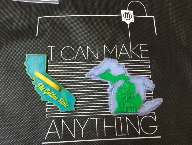
GeoLab3D Project: Bringing 21st Century Design to Elementary State Projects The GeoLab3D project was inspired by a simple yet effective elementary school requirement: learning about all 50 states in the United States. As part of the SF Makerbot Makeathon 2016, this submission unites traditional state projects with modern digital design elements. In the fourth or fifth grade, students typically research various aspects of their state, including its name, nickname, flower, tree, and more. GeoLab3D builds on this foundation by incorporating STEAM elements into the traditional unit. Students will research key historical and related elements, convert images to 3D models, generate text with specific information, and manipulate at least three individual objects to create a unique 3D model. This project integrates Social Science with STEAM components, making it an ideal learning experience for elementary students. To adapt this project for other grade levels, teachers can incorporate topographical detail, uniform scaling for larger map puzzles, or explore other regions or countries of the world. GeoLab3D is designed to be universally compatible and works seamlessly on Windows, OS X, Chromebook, and tablets. With a 3D printer and filament as the only required equipment beyond student workstations, this project is accessible to students with varying skill levels. Print Settings: * Printer Brand: MakerBot * Printer Model: MakerBot Replicator (5th Generation) * Rafts: Yes * Supports: Yes * Resolution: Medium * Infill: 10% Notes: The use of rafts and supports may vary greatly depending on object design. Layered colors require monitoring during the print process. Schools without in-site 3D printing capabilities can consider outsourcing prints or importing images into other 3D capable programs. Designing This Project: To complete this project, you'll need a 3D printer and student workstations with Tinkercad or similar 3D design software. Since GeoLab3D is designed for elementary school students, it's an ideal first 3D printing project for any age group. Students should find an image of their state outline online and convert it to an .svg file using an online SVG converter. The .svg file can then be imported into Tinkercad, where students can add the state nickname, a representative icon, or other elements that represent their state. The footprint of each state model should not exceed 15x15 cm (225 sq cm), allowing for reasonable printing times during school hours. Additionally, the height of each object should not exceed 10 cm. California with State Motto and Golden Bear in Tinkercad Geo Lab Project Overview: This project helps students learn to identify their state's shape and unique identifiers, reinforcing knowledge while introducing new technological tools for artistic expression. GeoLab3D is designed for elementary students but can be adapted for all age groups, making it an ideal first 3D printing experience. In addition to Social Science, this project incorporates STEAM elements, teaching students researching, importing, converting image files, 3D modeling, project management, and artistic expression. The project can be completed in a few hours or over several weeks (in shorter lessons), depending on time availability and student skill level. Detail of Michigan with colors layered during print process
With this file you will be able to print Geo Lab State Project with your 3D printer. Click on the button and save the file on your computer to work, edit or customize your design. You can also find more 3D designs for printers on Geo Lab State Project.