Gulf of Mexico in Relief
thingiverse
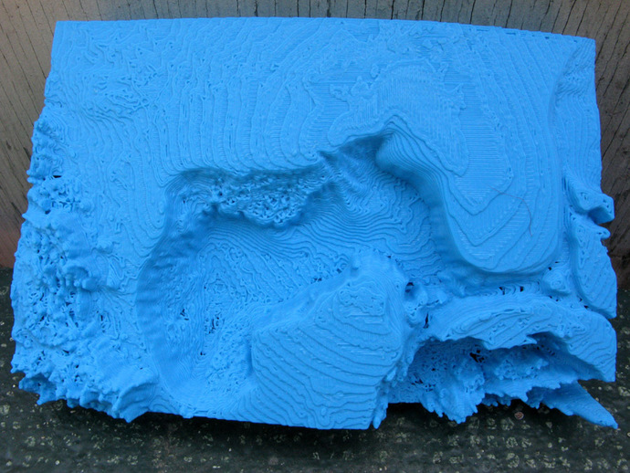
Here is a relief map that shows the bottom of the Gulf of Mexico. It's approximately 83 mm wide x 125 mm long x 29 mm deep. The horizontal scale is roughly 12 miles per mm and the vertical scale about 1 mile per 5 mm. The deepest parts of the gulf go down 2.5 miles which at this scale is about 13 mm. It was created from a version of the Scripps copyright data set, SRTM30_PLUS V8.0. See srtm30plus_copyright.txt for the license. DJ Moews's program "Globe" was used. The program and the data are available at http://djm.cc/dmoews.html The program globe can create planes that cut the earth into pieces and then output one of the pieces. The command that created a piece containing the Gulf of Mexico was: --output-piece 7 --map altitude data/srtm30plus 5400 2700 sbigendiandibyte --gridpoints 800 --map-scale 60 --cut-plane 0 1 -1.5 --cut-plane 0 1 -3 --cut-plane 4.5 -1 0 --cut-plane 4.5 1 0 --explode 100000 >gulf.stl The bottom portion of gulf.stl was discarded and the remainder of the file centered, scaled, and decimated to give gulf_of_mexico.stl. Both files are included. Instructions Using 2 shells and 2% infill gulf_of_mexico.stl takes about 4 hours to print on a Replicator. Gulf.stl has been scaled to fit the build platform. It takes about 3 hours to print. Gulf.stl makes the scale of the prints easy to understand as the pointed end touches the center of the earth. It comes from a globe 12 inches in diameter while gulf_of_mexico.stl comes from a globe 24 inches in diameter. Gulf_of_mexico.stl scales up nicely but of course scaled versions take much longer to print.
With this file you will be able to print Gulf of Mexico in Relief with your 3D printer. Click on the button and save the file on your computer to work, edit or customize your design. You can also find more 3D designs for printers on Gulf of Mexico in Relief.