Huge Lake Tahoe model
thingiverse
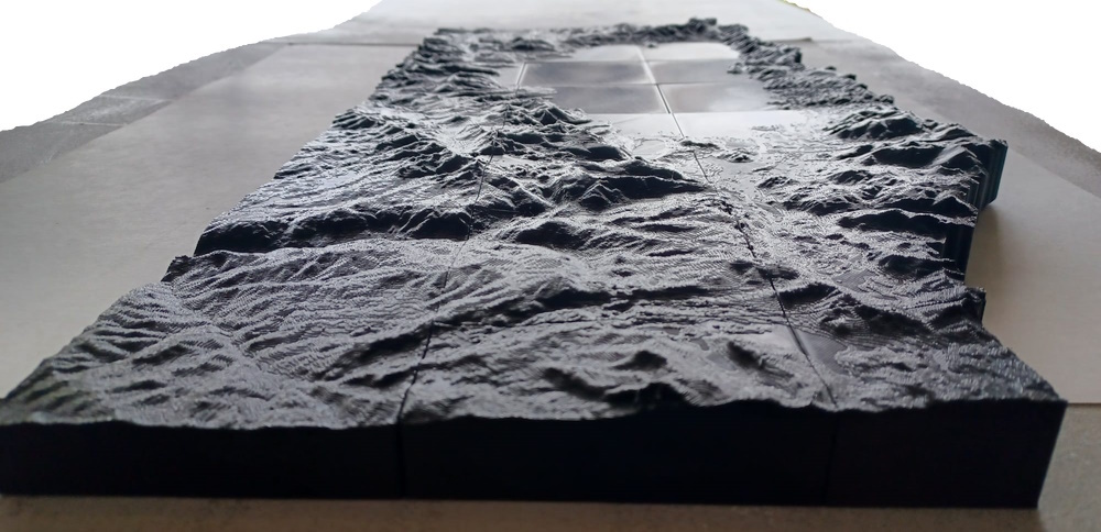
Took inspiration from Shapespeare's (https://www.thingiverse.com/shapespeare) Huge Yosemite Model: https://www.thingiverse.com/thing:351271 Pulled the topography data for Lake Tahoe and made 100mm x 100mm blocks of the topography. Each full size block is 10km x 10km. Height is based on sea level. Huge thanks to: - Shapespeare for his tutorial and his Yosemite model. - Fransisco for his DEMto3D QGIS plugin (https://github.com/jawensi/DEMto3D-QGIS-Plugin) My changes to the DEMto3D QGIS plugin to trim null/0 height data can be found here: https://github.com/astead/DEMto3D-QGIS-Plugin Future TODOs: - Expand west along hwy 80 and hwy 50? - Expand south a bit to fully include round top mountain? When I printed it, I placed the A blocks right next to the B blocks in the slicer, so they were already joined together. Here are the coordinates in case you want to get neighboring pieces, or need them for whatever reason. I'm also including the low point for each block so you can easily reduce the height of a group of blocks to the minimum for the group, while keeping the bottom aligned. Coordinates: (EPSG:26910, Low in meters rounded down) Block Xmin Xmax Ymin Ymax Low A1 767000 772000 4349000 4359000 2317 A2 767000 772000 4339000 4349000 2312 A3 767000 772000 4329000 4339000 2033 A4 767000 772000 4319000 4329000 2031 A5 767000 772000 4309000 4319000 2003 A6 767000 772000 4299000 4309000 2307 A7 767000 772000 4289000 4299000 NA A8 767000 772000 4279000 4289000 NA B1 757000 767000 4349000 4359000 1944 B2 757000 767000 4339000 4349000 1897 B3 757000 767000 4329000 4339000 1897 B4 757000 767000 4319000 4329000 1897 B5 757000 767000 4309000 4319000 1897 B6 757000 767000 4299000 4309000 1905 B7 757000 767000 4289000 4299000 1967 B8 757000 767000 4279000 4289000 2376 C1 747000 752000 4349000 4359000 1726 C2 747000 757000 4339000 4349000 1897 C3 747000 757000 4329000 4339000 1897 C4 747000 757000 4319000 4329000 1897 C5 747000 752000 4309000 4319000 1897 C6 747000 757000 4299000 4309000 1770 C7 747000 757000 4289000 4299000 1690 C8 747000 757000 4279000 4289000 1857 D1 737000 742000 4349000 4359000 1735 D2 737000 747000 4339000 4349000 1814 D3 737000 747000 4329000 4339000 1890 D4 737000 747000 4319000 4329000 1828 D5 737000 742000 4309000 4319000 1993 D6 737000 747000 4299000 4309000 1876 D7 737000 747000 4289000 4299000 1317 D8 737000 747000 4279000 4289000 1544 Citation for topography data: - Lake Tahoe Basin LiDAR. Distributed by OpenTopography. https://doi.org/10.5069/G9PN93H2 - 2014 USFS Tahoe National Forest Lidar. Distributed by OpenTopography. https://doi.org/10.5069/G9V122Q1 - U.S. Forest Service Region 5 Remote Sensing Lab Information Management Staff. (2022). USFS Freds Fire Lidar, CA 2015. Collected by Quantum Spatial. Distributed by OpenTopography. https://doi.org/10.5069/G94B2ZHP - USGS LPC CA NoCAL Wildfires B1 2018. Distributed by OpenTopography. https://portal.opentopography.org/usgsDataset?dsid=USGS_LPC_CA_NoCAL_Wildfires_B1_2018 - CA UpperSouthAmerican Eldorado 2019. Distributed by OpenTopography. https://portal.opentopography.org/usgsDataset?dsid=CA_UpperSouthAmerican_Eldorado_2019
With this file you will be able to print Huge Lake Tahoe model with your 3D printer. Click on the button and save the file on your computer to work, edit or customize your design. You can also find more 3D designs for printers on Huge Lake Tahoe model.