Mercury Globe 30x in 500,000 Facets
thingiverse
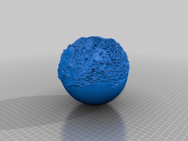
Mercury had half of its surface measured by the Messenger spacecraft. The 30x exaggeration factor reveals vast depression, similar to the Moon Globe 30x. PDS_VERSION_ID = "PDS3" / GENERAL DATA DESCRIPTION PARAMETERS / PRODUCT_VERSION_ID = "V1" DATA_SET_ID = "MESS-E/V/H-MLA-4-GDR-V1.0" PRODUCT_ID = "HDEM_2" STANDARD_DATA_PRODUCT_ID = "MLASCIENCEGDR" INSTRUMENT_HOST_NAME = "MESSENGER" INSTRUMENT_NAME = "MERCURY LASER ALTIMETER" INSTRUMENT_ID = "MLA" MISSION_PHASE_NAME = {"MERCURY 1 FLYBY","MERCURY 2 FLYBY", "MERCURY ORBIT","MERCURY ORBIT YEAR 2"} TARGET_NAME = MERCURY START_TIME = 2008-01-14 STOP_TIME = 2012-09-17 PRODUCT_CREATION_TIME = 2012-10-31 PRODUCT_RELEASE_DATE = 2013-03-08 PRODUCER_ID = MESSENGER_MLA_TEAM PRODUCER_FULL_NAME = "DAVID E. SMITH" PRODUCER_INSTITUTION_NAME = "NASA/GODDARD SPACE FLIGHT CENTER" DESCRIPTION = "This data product is a shape map (radius) of Mercury at a resolution of 21.293 km/pix by 21.293 km/pix, based on altimetry data acquired through the Mapping Phase by the MLA instrument. The preliminary MLA data are the source for this data set. The ground tracks were interpolated using the Generic Mapping Tools programs 'surface' and 'grdblend'. The map is in the form of a binary table with one row for each 0.5 degrees of latitude, pixel registered. Map values are relative to a radius of 2440 km. This label describes an IMG file in the form of a binary resampling to pixel registration. " OBJECT = UNCOMPRESSED_FILE FILE_NAME = "HDEM_2.IMG" RECORD_TYPE = FIXED_LENGTH FILE_RECORDS = 720 RECORD_BYTES = 1440 ^IMAGE = "HDEM_2.IMG" OBJECT = IMAGE NAME = HEIGHT DESCRIPTION = "Each sample represents height relative to a reference radius (OFFSET) and is generated using preliminary MLA data produced by the MLA team." LINES = 360 LINE_SAMPLES = 720 SAMPLE_TYPE = LSB_INTEGER SAMPLE_BITS = 16 UNIT = METER SCALING_FACTOR = 0.5 OFFSET = 2440000 END_OBJECT = IMAGE / Conversion from Digital Number to HEIGHT, i.e. elevation in meters, is: / / HEIGHT = (DN SCALING_FACTOR). / / The conversion from Digital Number to PLANETARY_RADIUS in meters is: / / PLANETARY_RADIUS = (DN SCALING_FACTOR) + OFFSET / END_OBJECT = UNCOMPRESSED_FILE OBJECT = IMAGE_MAP_PROJECTION ^DATA_SET_MAP_PROJECTION = "DSMAP.CAT" MAP_PROJECTION_TYPE = "SIMPLE CYLINDRICAL" MAP_RESOLUTION = 2 A_AXIS_RADIUS = 2440. B_AXIS_RADIUS = 2440. Thank you, Planetary Data System (PDS) Alan Folmsbee, Globemaker Instructions The Mercury data is available for you here:http://pds-geosciences.wustl.edu/messenger/mess-e_v_h-mla-3_4-cdr_rdr-data-v1/messmla_2001/gdr/img/ That digital elevation data was used to make my Mercury Globe 3D model files in .stl format. My secret Perl program can be licensed for your custom: sub fill_array_630 { open(INFILE, "$height_file_in") or die "Can't open $height_file_in: $!"; print "Making height array... Count to $row_max "; convert binary mercury heights into a ascii array: mercury_surface $counter = 0; binmode(INFILE); for ($row=0; $row
With this file you will be able to print Mercury Globe 30x in 500,000 Facets with your 3D printer. Click on the button and save the file on your computer to work, edit or customize your design. You can also find more 3D designs for printers on Mercury Globe 30x in 500,000 Facets.