Modeling Topography and Erosion with 3D Printing
thingiverse
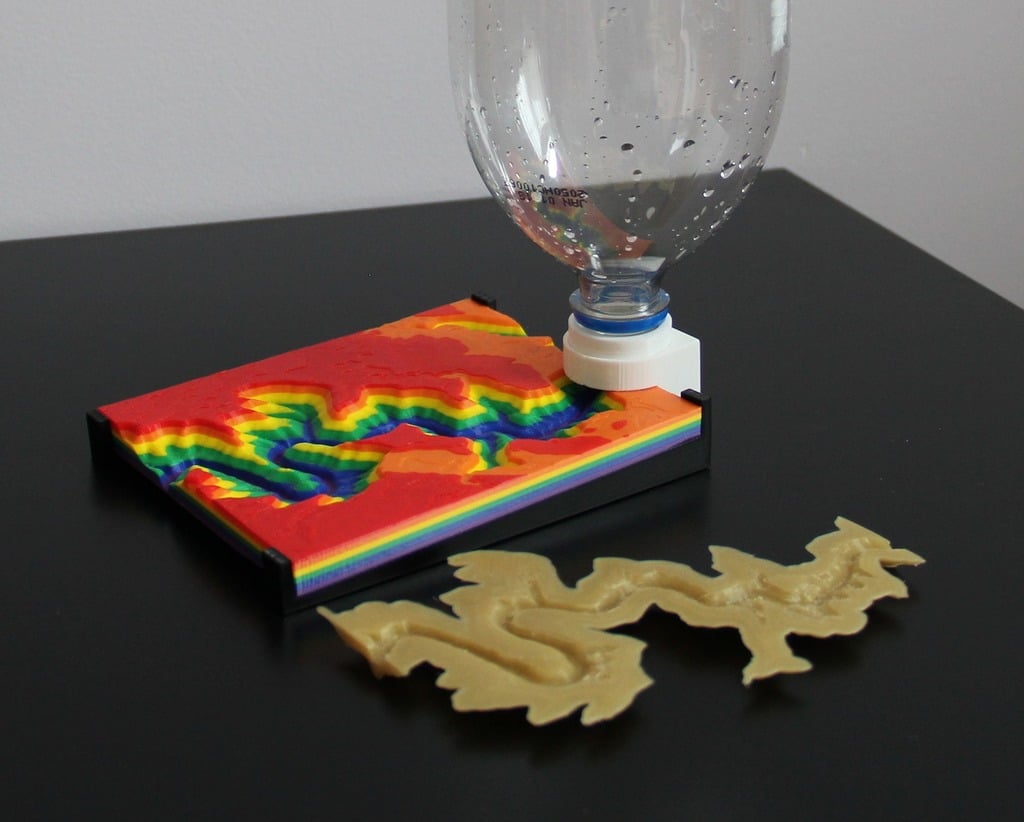
Modeling Topography and Erosion with 3D Printing is a project designed to demonstrate the effects of river erosion on the Grand Canyon. This model serves as a visual aid for students studying geography and earth science, allowing them to create a scale terrain model of this region. Included in the files are 3D printable models that enable students to build a scale terrain model of the Grand Canyon area and all necessary accessories to simulate a water source. By using rigid plastic PLA to print the Grand Canyon and water-soluble PVA to print a River Valley within it, students can observe how the erosion process unfolds. As participants pour water through the river, the PVA dissolves, gradually exposing the canyon underneath. During this experiment, students will witness natural formations and identify geographic terms to comprehend how these structures come into being. Update #1 - 4/12/2018: An experimental two-part mold for the PVA river has been uploaded, allowing users to cast the river insert from a different material or liquid PVA. This is still in its early testing phase; use at your own risk. The mold features four mounting holes for standard M3 (x12mm or longer) bolts. Update #2 - 3/28/2019: A text document detailing exactly how to make the Grand Canyon and PVA insert using Blender 2.78 has been included in the files. Advanced users can consult this guide to create their own topographic models. Update #3 - 6/27/2019: The source Blender 2.78 file used to create all terrain model pieces is now available, including original geometry, starter river shape, blank PVA insert, and boolean cubes for adjusting the river's depth or making new inserts. A Grand Canyon model separated into six colors has also been uploaded. In the Thing Files, raw geometry of the starter river, an extruded starter river for booleans, and a blank PVA insert are available for creating custom molds for new erosion substrates. Share your experiment and experience with the project by posting images, videos, tips, tricks, or suggestions. Awards, Accolades, and Mentions - Pinshape Create to Educate Lesson Plan Contest - 1st Place Winner - Pinshape Featured Design - December 1, 2017 - Make Magazine Blog Article - December 18, 2017 - Cults 3D Selection - December 2017 - MatterHackers Minute - Create to Educate Design Challenge Review https://pinshape.com/blog/announcing-create-educate-lesson-plan-contest-winners/ https://pinshape.com/blog/pinshape-featured-designs-december-1st/ https://makezine.com/2017/12/18/science-simulation-3d-printing/ https://cults3d.com/en/creations/selected https://www.youtube.com/watch?v=S_rikCwHumk Timelapse video: https://www.youtube.com/watch?v=DhQ9V3SRjRw Follow me on Instagram to see more cool stuff! :D https://www.instagram.com/roberthemlich/ This lesson plan is written with an emphasis on the Common Core Science Standards for Michigan. The guide follows classroom goals set by the "Science Course/Credit Requirements" document to engage student interest in STEM subjects. http://www.michigan.gov/documents/mde/Science_CourseCredit_466083_7.pdf
With this file you will be able to print Modeling Topography and Erosion with 3D Printing with your 3D printer. Click on the button and save the file on your computer to work, edit or customize your design. You can also find more 3D designs for printers on Modeling Topography and Erosion with 3D Printing.