Relief Map Oroville Dam
thingiverse
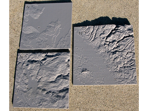
A group of space agencies, including NASA, has made digital elevation models for most of the earth. They are available as 1 degree squares (latitude and longitide) with pixels at intervals of 1 second - "Aster Global Dems". The square with lower left coordinates of 39 N 122 W has the Oroville dam near its center. The square was downloaded using Earth Explorer - https://earthexplorer.usgs.gov/ One is expected to state that "ASTER GEDEM is a product of METI and NASA" Here are 3 relief maps calculated from the 39N 122W square. A representation of the whole square shows the Sacramento valley and the mountain range east of it; a prominent feature of the valley, the Sutter Buttes, is clearly seen. The position of the dam is marked with an asterisk. The danger faced by residents of Sacramento valley is obvious. A close up using data at 1 second intervals shows the dam and a version a bit further away shows a large part of lake Oroville. Print Settings Printer Brand: MakerBot Printer: MakerBot Replicator (5th Generation) Rafts: Yes Supports: No Resolution: 0.2 mm Technical Details The data comes as a GeoTIFF file with an array of 3601 by 3601 signed 16 bit integers representing elevation in meters. The files can easily be converted to "raw format" with, for example, Adobe Photoworkshop. Simple fortran programs, included, were used to pick out portions of the data to convert to openSCAD surface files. The surface files were read by openSCAD programs, included, and output as stl relief maps. The maps are at widely different scales. The sides of the map representing the whole square are about 60 by 47 miles long. The closeup map represents an area about 3.3 by 2.6 miles. The intermediate map shows an area about 13 by 10 miles.
With this file you will be able to print Relief Map Oroville Dam with your 3D printer. Click on the button and save the file on your computer to work, edit or customize your design. You can also find more 3D designs for printers on Relief Map Oroville Dam.