Relief Maps of Bora Bora
thingiverse
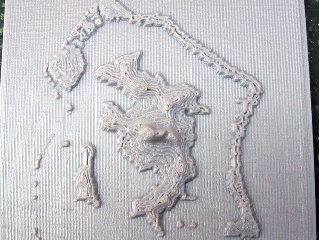
Here is the asked for relief map of Bora Bora - see thing:106099 - More Hawaiian Relief Maps. The data came from the Aster Global Dem which can be accessed via Earth Explorer. http://earthexplorer.usgs.gov/ The DEM is for non commercial use. One must register and agree to not redistribute the data and include the following statement with the description of your results: "Aster GDEM is a product of METI and NASA." It is also noted that the data may contain anomalies. Aster GDEM files are global elevation data sets in geotiff format. A 1 arc-second resolution file, ASTGTM2_S17W152_dem.tif, was downloaded and converted to "raw" format with Adobe Photoshop. The raw format file contains 3601 rows and 3601 columns of two byte signed integers. See - http://www.jspacesystems.or.jp/ersdac/GDEM/ver2Validation/GDEM_QuickGuide2.pdf for a quick guide and http://www.jspacesystems.or.jp/ersdac/GDEM/E/1.html for an overview A fortran program similar to those in things 118327 and 121275 was used to treat the raw file. Two stl files are provided: Bora_bora_archipelago.stl Bora_bora_central_island.stl Instructions The maps are best printed directly on the build platform. Bora_bora_archipelago.stl is 85 mm wide (510 arc-seconds in longitude) and 90 mm high (540 arc-seconds in latitute). Bora_bora_central_island.stl is 59 mm wide (200 arc-seconds in longitude) and 94 mm high (310 arc-seconds in latitute). The height is as follows: a base of 2 mm followed by a jump up of 1 mm at sea level and then 1 mm for each 133 meters. The highest point in the models is 7.5 mm or 7.5 - 2 - 1 = 4.5 mm or 600 meters.
With this file you will be able to print Relief Maps of Bora Bora with your 3D printer. Click on the button and save the file on your computer to work, edit or customize your design. You can also find more 3D designs for printers on Relief Maps of Bora Bora.