Santa Cruz Mountain Model, California
thingiverse
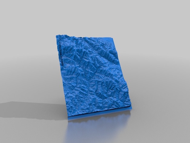
This quadrangle from the US Geological Survey is called Castle Rock Ridge. The town of Boulder Creek is in a valley in this 3D model. The database is called SDTS, the Spatial Data Transfer Standard. This has 30 meter data point spacing. If you want a 3D model of a quad that you like more than this one, it will cost you. There is also a 10 meter SDTS database. The ThingView shows a blue simulation where the flatlands at top right are in Los Gatos, California and the valley pointing into the bottom left is the San Lorenzo River Valley with Boulder Creek. The gray image is the quad from a lower angle. Instructions The SDTS files were input to my Perl program and out pops an stl file! Populate the California terrain heights into the surface array open(INFILE, "$height_file_in") or die "Can't open $height_file_in: $!"; while ($line=) { @height = split(/s+/,$line,13); $row = $row_max - (int(($height[1] - $lat_start)/$meters)); $column = int(($height[0] - $lon_start)/$meters); $filtered_surface[$column][$row] = $surface[$column][$row] + $exag*$height[2]; } You can get SDTS data files for each USA state here:http://store.geocomm.com/data/state/ close(INFILE);
With this file you will be able to print Santa Cruz Mountain Model, California with your 3D printer. Click on the button and save the file on your computer to work, edit or customize your design. You can also find more 3D designs for printers on Santa Cruz Mountain Model, California.