Tactile Map for Taipei Metro Route
pinshape
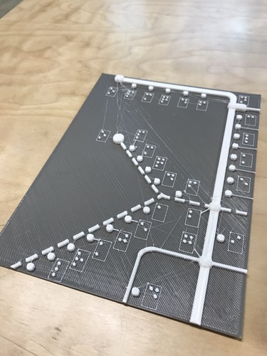
While Taipei Metro expands from 1 line to 5 lines has made city commute more convenient, it has also made transferring between different lines more challenging for my visually impaired friends. This is the tactile map for Taipei Metro Route that my friend wanted me to make for him, so the braille is in traditional Chinese in the version, and I will make English version after some iterations. The current version of the map consisted of 4 parts, each part is about 18x14cm. The parts can be connected through the oval symbol (representing Transfer Stations) by the edges. The full station names will take too much space of the map, so I only leave the first letter ( in Mandarin Phonetic Symbol sequences) next to each station. The stations names are grouped by different metro lines for quick reference in a separate station list, with representing line examples. Different Lines are represented by different kind of lines: Red Line—single thick line Blue Line—single thick dot line Orange Line—single thin dot line Brown Line—double thin line Green Line—single thin line When using the map, the user can firstly find out the representing symbol and line of the start station in the station list, knowing which line (both Metro line and tactile line) of station is on, then find out the end station in the same manner. With the shape of the line in mind, the user can find out where to make the transfer and how many stops is it from the current station. I’ve printed and checked this beta version with my blind friend about the height of the dots and lines, which he confirmed distinguishable, though some spacings of the braille need to be fine tuned for perfect readability. Some of the edges are still too sharp, and flexible filament didn't seem to be of much help. Later I will try to print with PolySmooth and vaporized the prints with Polysher, which is now on the way to my place. The whole sets of the map are still too large to carry. So as a final job, after my blind friend is satisfied with the arrangement and texture, I will add hinges or paste the prints on soft clothe to make it foldable or book like. The model is constructed in Tinkercad Beta, whose ability to input braille directly is really a time saver. For Chinese braille conversion, I use the web tools designed by a visually impaired Taiwan engineer : http://coscell.molerat.net/brl/c2b.php These two sites has made creating 3D braille a lot easier, kudos to the guys behind them!
With this file you will be able to print Tactile Map for Taipei Metro Route with your 3D printer. Click on the button and save the file on your computer to work, edit or customize your design. You can also find more 3D designs for printers on Tactile Map for Taipei Metro Route.