Thunderhill Raceway Elevation Model
thingiverse
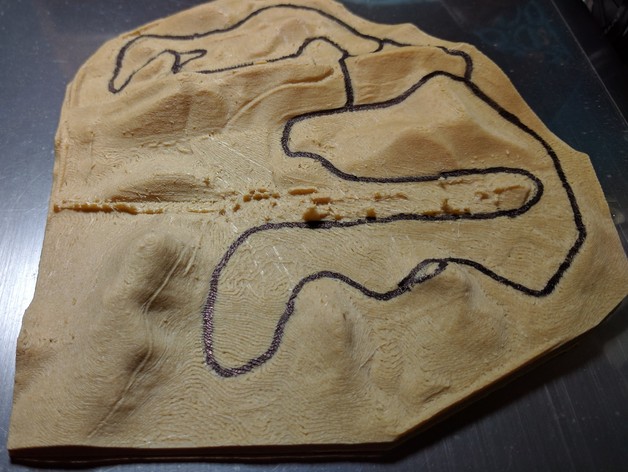
A topological model of Thunderhill Raceway Park based on data from Kairos Aerospace as part of the Self Racing Car project. Thunderhill has many interesting terrain changes that affect how you drive it. Looking at it in 3D really allows you to understand those terrain changes. I manually drew the track using a marker -- I couldn't find an easy way to build that into the print. Print Settings Printer Brand: LulzBot Printer: Mini Rafts: No Supports: No Resolution: 0.12mm Infill: 20% Notes: This will take a while to print. On my Lulzbot Mini, it takes 8 hours or so. You can have a very fine resolution, but it is probably good to have a thick bottom layer. Post-Printing Trace out the track After printing out, look it up in Google maps or get a track map and trace out the path in pencil. Then trace it with a marker. How I Designed This How I made this Started by downloading the GeoTiff from here. This is a huge file about 6000 x 6000 pixels. I then loaded it into QGIS and used its raster tools to cut the resolution to around 1500 x 1500. I then used phstl to convert the reduced resolution GeoTIFF to an STL file. This file was still huge: about 150MB! I then pulled this into MeshMixer and extruded it to turn that surface into a solid, also increasing z value by a factor of 4. OK, now it's 330MB and 6 million polygons! So then I used MeshMixer to reduce the polygon count by 85% -- finally resulting in a file that is 44MB and contains about a million polygons.
With this file you will be able to print Thunderhill Raceway Elevation Model with your 3D printer. Click on the button and save the file on your computer to work, edit or customize your design. You can also find more 3D designs for printers on Thunderhill Raceway Elevation Model.