United States by Tornados
thingiverse
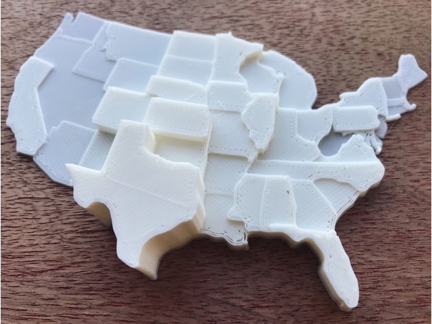
Map of the USA showing prevalence of tornados in each state averaged over two decades. Data gathered from: https://www.ncdc.noaa.gov/climate-information/extreme-events/us-tornado-climatology Also available through Shapeways: http://shpws.me/NdwO Customized version of http://www.thingiverse.com/thing:209005 Created with Customizer! http://www.thingiverse.com/apps/customizer/run?thing_id=209005 Instructions Using the following options: data9 = 4.8 data8 = 29.4 data7 = 54.6 data6 = 1.2 data5 = 1.6 data4 = 49.5 data3 = 10.6 data2 = 38.2 data1 = 4.6 data0 = 47.1 wall_thickness = 0 x_size_limit = 130 z_size_limit = 20 lower_bound = 0 data39 = 29.1 data38 = 32.6 data37 = 23.3 data36 = 1 data35 = 16 data34 = 2.8 data33 = 65.4 data32 = 19.2 data31 = 31 data30 = 29.1 floor_thickness = 0 y_size_limit = 130 data19 = 14.7 data18 = 1.6 data17 = 9.9 data16 = 2.2 data15 = 36.9 data14 = 24.2 data13 = 92.4 data12 = 49.2 data11 = 24.6 data10 = 54 upper_bound = 150 data29 = 9.6 data28 = 9.7 data27 = 2 data26 = 1.2 data25 = 1.9 data24 = 54.6 data23 = 9.3 data22 = 46.7 data21 = 45.1 data20 = 41.9 inflation = 1.0001 data47 = 10.9 data46 = 23.5 data45 = 2.4 data44 = 2.5 data43 = 17.7 data42 = 1 data41 = 2.5 data40 = 146.7
With this file you will be able to print United States by Tornados with your 3D printer. Click on the button and save the file on your computer to work, edit or customize your design. You can also find more 3D designs for printers on United States by Tornados.