Vancouver - British Columbia - 3D Map - Topographic
cults3d
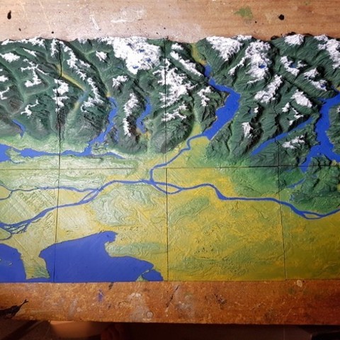
This is a 3D Topographical Map of Vancouver, British Columbia, Canada. Taken from Google Maps data. It is sized into 16 sections and should fit perfectly onto most 3D printers. You can easily just scale it down or up depending on your printer. Just make sure that you remember the scale you use when slicing each section. The images of the printed/painted map are of pieces 1 to 8. Pieces 9 to 16 go directly North (Up) from the painted map. Order = Left to Right (1-4) and consecutively in the same order above (5-8, etc.) [13-14-15-16] [9 - 10-11-12] [5 - 6 - 7 - 8 ] [1 - 2 - 3 - 4 ] Project Name: 3D Topographical Map of Vancouver and the Coastal Mountains Overview & Background: I live in Vancouver and love every part of it. When people talk about this area they always speak of the mountains and terrain, but really only have post-cards and FLAT maps to look at. This shows how vertical everything is around the city. With the ocean being the lowest parts of the map. Objectives: Students will get a birds eye view of the area. Seeing and FEELING the differences in terrain height. It's important to know where the flooding areas are and why they flood based on their height. This city and area is known for it's terrain, yet you have to travel very far and into difficult (impossible) areas to see it all. Better than just a computer screen, we can see everything with a full 3D ability. Audiences: All ages can appreciate it to different degrees. The primary audience is grades 5 and up - based on common Geography lessons. Subjects: Geography, Sciences (Earth Science), Art - for creating and painting the map. Skills Learned (Standards): Precision printing, or the pieces will not fit together properly. Possible wood working for mounting the map plates, and painting the map if wanted. Lesson/Activity: Depending on which parts of the map you would like - print out in PLA for the least number of issues with warping. Since it is a very flat and large base on each piece, PLA will not warp like ABS. Number each piece on the back with a marker to ensure that you do not mix them up, with an arrow showing North or a similar direction for all pieces. The pieces can be mounted with glue to a wall, board, or anything you would like. Another option is to have the pieces kept loose and put together when needed for geography lessons. When discussing the Vancouver and Coastal Mountains, or tectonic plate shifting, or other topics you can use this map. Duration: Each plate can take from 1 to 4+ hours based on the height of the plate and size of printing scale. Preparation: You need to have access to or have a 3D printer. There are websites that offer printing services as well, and will ship the pieces to you. Once the pieces are created how they are mounted (or not) is up to you. The rest of the preparation is determined whether the pieces are loose or mounted. References: google.maps topographical data was used in creating these .stl files. Rubric & Assessment: Geography - students will have discussed how geography of the Vancouver and local areas has affected the region with: commerce, water level changes, weather, and any other topics that the instructor finds relevant. Students will then use the map to locate where various aspects discussed in the lesson take place, name regions, and other points of interest. MakerEdChallenge2 ScienceProject ArtProject DesignProject Check out my Youtube channelhttps://www.youtube.com/channel/UCZ64RaAsrJ9v66Rt3bDEO2w Check out my Websitehttp://proteanman.com Follow me on Twitterhttps://twitter.com/Protean_Man Enjoy!
With this file you will be able to print Vancouver - British Columbia - 3D Map - Topographic with your 3D printer. Click on the button and save the file on your computer to work, edit or customize your design. You can also find more 3D designs for printers on Vancouver - British Columbia - 3D Map - Topographic.