Worcester Polytechnic Institute (WPI) campus with display stand
prusaprinters
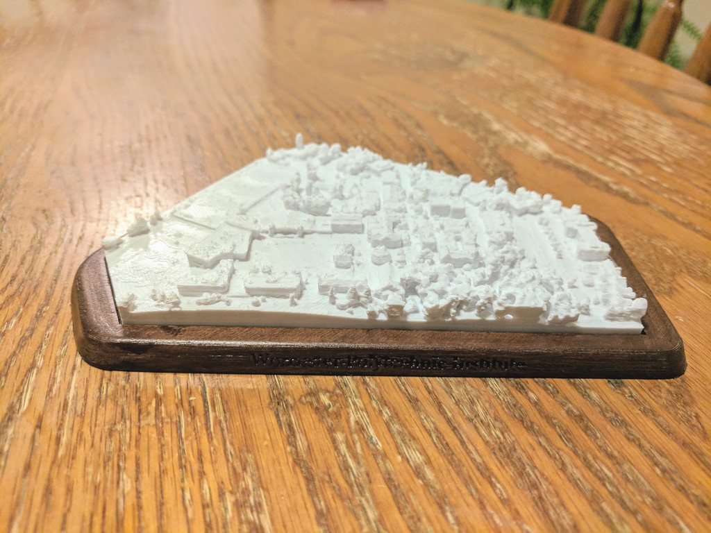
<p>This is a photogrammetric model of the Worcester Polytechnic Institute (WPI) Campus. It goes from the Alumni Football field, all the way over to East Hall.</p> <p>This also includes a display base for the model to stand on. The text 'Worcester Polytechnic Institute' is engraved onto the front edge of the stand. If you turn the stand over to view the bottom, the WPI Seal is engraved on the bottom.</p> <p>I printed the base in hatchbox woodfill, and then sanded, stained, and sealed it to give it a nice wooden finish.</p> <h3> Print Settings</h3> <p><strong>Printer Brand:</strong></p> <p>Creality</p> <p><p class="detail-setting printer"><strong>Printer: </strong> <div><p>Ender 3</p></div><strong>Rafts:</strong></p> <p>No</p> <p><p class="detail-setting supports"><strong>Supports: </strong> <div><p>No</p></div><strong>Resolution:</strong></p> <p>.08</p> <p><p class="detail-setting infill"><strong>Infill: </strong> <div><p>20%</p></div><br/> <strong>Filament:</strong><br/> [</p> <h3>](http://www.amazon.com/s?url=search-alias&field-keywords=eSun+pla%2B&tag=thingiverse09-20)[ eSun](https://www.amazon.com/s?k=esun+filament&linkCode=ll2&tag=thingiverse09-20&linkId=ee95e18399f58ca8cf2c8c2b4b912c0c&language=en_US&ref_=as_li_ss_tl) pla+ cool white <br/> <p class="detail-setting notes"><strong>Notes: </strong> </p><div><p>Might be good to turn on z-hop to make sure some of the tiny structures like trees do not get knocked over.</p></div> How I Designed This</h3> <p><strong>Photogrammetry Using Google Earth</strong></p> <p><div><p>While I do not have a drone to do 'real' aerial photogrammetry, I do have the next best thing: Google Maps / Google Earth.</p> Google Earth has done a great job of creating surprisingly accurate 3D views of most buildings. Even the land is modeled to an extent, so you can view the topology of most areas. You can see this in the WPI model, where the hills are preserved (though they may not be to scale).</div></p> <p>While Google Earth unfortunately doesn't have an 'export' ability built in to it to download an area, since we can pan around in 3D, we can 'pretend' we are a drone. By taking several (hundred) screenshots of a 3D area of interest in Google Earth from different angles, heights, zoom levels, we can use open source (or paid) photogrammetry software to analyze all of the photos and generate a 3D model for us.</p> <p>You can try using <a href="https://alicevision.github.io/#meshroom">meshroom</a></p> <p>Google Earth has a built in 'screenshot' button to help make this easier and configure the resolution of each shot. If someone was determined enough, this process could probably be automated using the API or just automating the key and mouse movements.</p> </p></p></p> Category: Scans & Replicas
With this file you will be able to print Worcester Polytechnic Institute (WPI) campus with display stand with your 3D printer. Click on the button and save the file on your computer to work, edit or customize your design. You can also find more 3D designs for printers on Worcester Polytechnic Institute (WPI) campus with display stand.